
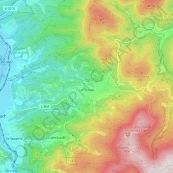
Loffenau topographic map
Interactive map
Click on the map to display elevation.
About this map
Name: Loffenau topographic map, elevation, terrain.
Average elevation: 1,493 ft
Minimum elevation: 489 ft
Maximum elevation: 3,107 ft
Other topographic maps
Click on a map to view its topography, its elevation and its terrain.
Gernsbach
Duitsland > Baden-Württemberg > Landkreis Rastatt
Gernsbach, Vereinbarte Verwaltungsgemeinschaft Gernsbach, Landkreis Rastatt, Baden-Württemberg, 76593, Duitsland
Average elevation: 1,765 ft
Kleines Matterhorn
Duitsland > Baden-Württemberg > Landkreis Rastatt > Forbach
Kleines Matterhorn, Forbach, Landkreis Rastatt, Baden-Württemberg, 76599, Duitsland
Average elevation: 1,683 ft
Bühl
Duitsland > Baden-Württemberg > Landkreis Rastatt
Bühl, Vereinbarte Verwaltungsgemeinschaft Bühl, Landkreis Rastatt, Baden-Württemberg, 77815, Duitsland
Average elevation: 928 ft
Bühlertal
Duitsland > Baden-Württemberg > Landkreis Rastatt > Bühlertal
Bühlertal, Landkreis Rastatt, Baden-Württemberg, 77830, Duitsland
Average elevation: 1,516 ft
Biberacher Schwallung
Duitsland > Baden-Württemberg > Landkreis Rastatt > Forbach > Biberach
Biberacher Schwallung, Biberach, Forbach, Landkreis Rastatt, Baden-Württemberg, 76596, Duitsland
Average elevation: 2,654 ft