
Make a donation
Gear up for your next adventure:
As an Amazon Associate, this site earns from qualifying purchases at no extra cost to you.
Burleson topographic map
Click on the map to display elevation.
Make a donation
Gear up for your next adventure:
As an Amazon Associate, this site earns from qualifying purchases at no extra cost to you.
Burleson
As of 2010, Burleson had a total area of 26.07 square miles (67.52 km2), of which 26.01 square miles (67.36 km2) were land and 0.07 square miles (0.17 km2), or 0.25%, were water. Village Creek, a tributary of the Trinity River, flows to the northeast through the city. Most of Burleson lies between 700 and 800 feet (210 and 240 m) in elevation.
Make a donation
Gear up for your next adventure:
As an Amazon Associate, this site earns from qualifying purchases at no extra cost to you.
About this map
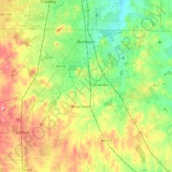
Name: Burleson topographic map, elevation, terrain.
Location: Burleson, Johnson County, Texas, United States (32.43272 -97.43155 32.57192 -97.24890)
Average elevation: 801 ft
Minimum elevation: 633 ft
Maximum elevation: 1,024 ft
Johnson County trails, hiking, mountain biking, running and outdoor activities
Make a donation
Gear up for your next adventure:
As an Amazon Associate, this site earns from qualifying purchases at no extra cost to you.
Other topographic maps
Click on a map to view its topography, its elevation and its terrain.