
Make a donation
Gear up for your next adventure:
As an Amazon Associate, this site earns from qualifying purchases at no extra cost to you.
Brandon topographic map
Click on the map to display elevation.
Make a donation
Gear up for your next adventure:
As an Amazon Associate, this site earns from qualifying purchases at no extra cost to you.
About this map
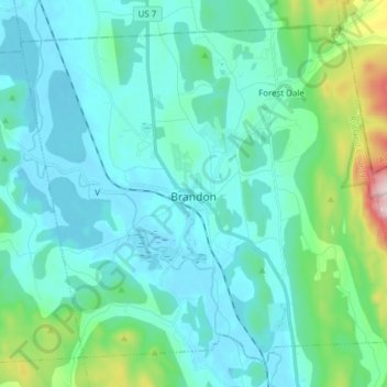
Name: Brandon topographic map, elevation, terrain.
Location: Brandon, Rutland County, Vermont, United States (43.75074 -73.15639 43.84719 -73.00352)
Average elevation: 663 ft
Minimum elevation: 328 ft
Maximum elevation: 2,513 ft
Rutland County trails, hiking, mountain biking, running and outdoor activities
Make a donation
Gear up for your next adventure:
As an Amazon Associate, this site earns from qualifying purchases at no extra cost to you.
Other topographic maps
Click on a map to view its topography, its elevation and its terrain.
Make a donation
Gear up for your next adventure:
As an Amazon Associate, this site earns from qualifying purchases at no extra cost to you.
Make a donation
Gear up for your next adventure:
As an Amazon Associate, this site earns from qualifying purchases at no extra cost to you.
Billings Mobile Manor
United States > Vermont > Rutland County > Rutland City
Average elevation: 692 ft
Make a donation
Gear up for your next adventure:
As an Amazon Associate, this site earns from qualifying purchases at no extra cost to you.
West Tinmouth
United States > Vermont > Rutland County > Tinmouth > West Tinmouth
Average elevation: 1,375 ft
Chittenden Reservoir
United States > Vermont > Rutland County > Chittenden
Average elevation: 1,552 ft