
Cedar Hill topographic map
Interactive map
Click on the map to display elevation.
About this map
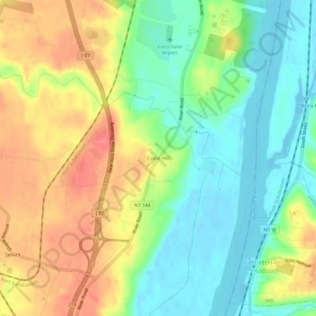
Name: Cedar Hill topographic map, elevation, terrain.
Average elevation: 95 ft
Minimum elevation: -13 ft
Maximum elevation: 210 ft
Other topographic maps
Click on a map to view its topography, its elevation and its terrain.
Wemple
United States > New York > Albany County > Town of Bethlehem
Wemple, Town of Bethlehem, Albany County, New York, 12077, United States
Average elevation: 105 ft
Beckers Corners
United States > New York > Albany County > Town of Bethlehem
Beckers Corners, Town of Bethlehem, Albany County, New York, 12158, United States
Average elevation: 161 ft
Bethlehem Heights
United States > New York > Albany County > Town of Bethlehem
Bethlehem Heights, Town of Bethlehem, Albany County, New York, 12161, United States
Average elevation: 174 ft
South Albany
United States > New York > Albany County > Town of Bethlehem
South Albany, Town of Bethlehem, Albany County, New York, 12161, United States
Average elevation: 210 ft
Houcks Corners
United States > New York > Albany County > Town of Bethlehem
Houcks Corners, Town of Bethlehem, Albany County, New York, 12054, United States
Average elevation: 194 ft
Spawn Hollow
United States > New York > Albany County > Town of Bethlehem
Spawn Hollow, Town of Bethlehem, Albany County, New York, 12607, United States
Average elevation: 308 ft
Slingerlands
United States > New York > Albany County > Town of Bethlehem
Slingerlands, Town of Bethlehem, Albany County, New York, 12159, United States
Average elevation: 213 ft
South Bethlehem
United States > New York > Albany County > Town of Bethlehem
South Bethlehem, Town of Bethlehem, Albany County, New York, 12161, United States
Average elevation: 236 ft
Delmar
United States > New York > Albany County > Town of Bethlehem
Delmar, Town of Bethlehem, Albany County, New York, 12054, United States
Average elevation: 200 ft
Glenmont
United States > New York > Albany County > Town of Bethlehem
Glenmont, Town of Bethlehem, Albany County, New York, 12077, United States
Average elevation: 92 ft
Bethlehem Center
United States > New York > Albany County > Town of Bethlehem
Bethlehem Center, Town of Bethlehem, Albany County, New York, 12077, United States
Average elevation: 157 ft
Selkirk
United States > New York > Albany County > Town of Bethlehem
Selkirk, Town of Bethlehem, Albany County, New York, 12158, United States
Average elevation: 144 ft