
Bronckhorst topographic map
Interactive map
Click on the map to display elevation.
About this map
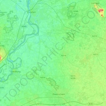
Name: Bronckhorst topographic map, elevation, terrain.
Location: Bronckhorst, Geldern, Niederlande (51.96798 6.11081 52.13771 6.47577)
Average elevation: 43 ft
Minimum elevation: 3 ft
Maximum elevation: 167 ft
Other topographic maps
Click on a map to view its topography, its elevation and its terrain.
Bronkhorst
Niederlande > Geldern > Bronckhorst
Bronkhorst, Bronckhorst, Geldern, Niederlande
Average elevation: 26 ft
Laag-Keppel
Niederlande > Geldern > Bronckhorst
Laag-Keppel, Bronckhorst, Geldern, Niederlande
Average elevation: 36 ft