
Shenendoah City topographic map
Interactive map
Click on the map to display elevation.
About this map
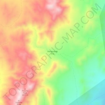
Name: Shenendoah City topographic map, elevation, terrain.
Location: Shenendoah City, Beaver County, Utah, United States (38.33219 -113.15718 38.37219 -113.11718)
Average elevation: 6,073 ft
Minimum elevation: 5,223 ft
Maximum elevation: 6,880 ft
Other topographic maps
Click on a map to view its topography, its elevation and its terrain.
Minersville
United States > Utah > Beaver County
Minersville, Beaver County, Utah, 84752, United States
Average elevation: 5,528 ft
Dead Horse Point
United States > Utah > Beaver County
Dead Horse Point, Beaver County, Utah, United States
Average elevation: 5,299 ft
Milford
United States > Utah > Beaver County
Milford, Beaver County, Utah, 84751, United States
Average elevation: 5,003 ft