
Gordon Lick Knob topographic map
Interactive map
Click on the map to display elevation.
About this map
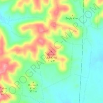
Name: Gordon Lick Knob topographic map, elevation, terrain.
Location: Gordon Lick Knob, Casey County, Kentucky, United States (37.49975 -84.86806 37.49985 -84.86796)
Average elevation: 1,168 ft
Minimum elevation: 1,030 ft
Maximum elevation: 1,394 ft
Other topographic maps
Click on a map to view its topography, its elevation and its terrain.
Dunnville
United States > Kentucky > Casey County
Dunnville, Casey County, Kentucky, 42528, United States
Average elevation: 807 ft
Windsor
United States > Kentucky > Casey County
Windsor, Casey County, Kentucky, 42565, United States
Average elevation: 1,102 ft
Middleburg
United States > Kentucky > Casey County
Middleburg, Casey County, Kentucky, 42541, United States
Average elevation: 942 ft
Bethelridge
United States > Kentucky > Casey County
Bethelridge, Casey County, Kentucky, 42516, United States
Average elevation: 1,129 ft
Creston
United States > Kentucky > Casey County
Creston, Casey County, Kentucky, United States
Average elevation: 1,024 ft
Yosemite
United States > Kentucky > Casey County
Yosemite, Casey County, Kentucky, 42541, United States
Average elevation: 935 ft