
Krebet topographic map
Interactive map
Click on the map to display elevation.
About this map
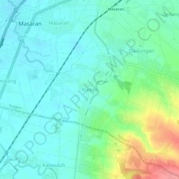
Name: Krebet topographic map, elevation, terrain.
Location: Krebet, Sragen, Central Java, Java, Indonesia (-7.50728 110.92172 -7.46728 110.96172)
Average elevation: 338 ft
Minimum elevation: 256 ft
Maximum elevation: 594 ft
Other topographic maps
Click on a map to view its topography, its elevation and its terrain.
Kedawung
Indonesia > Central Java > Sragen
Kedawung, Sragen, Central Java, Java, Indonesia
Average elevation: 531 ft
Majenang
Indonesia > Central Java > Sragen
Majenang, Sragen, Central Java, Indonesia
Average elevation: 328 ft