
Niederdorf topographic map
Interactive map
Click on the map to display elevation.
About this map
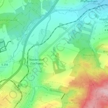
Name: Niederdorf topographic map, elevation, terrain.
Average elevation: 1,355 ft
Minimum elevation: 1,175 ft
Maximum elevation: 1,801 ft
Other topographic maps
Click on a map to view its topography, its elevation and its terrain.
Stollberg
Duitsland > Saksen > Erzgebirgskreis > Stollberg/Erzgebirge
Stollberg, Stollberg/Erzgebirge, Stollberg/Erzgeb., Erzgebirgskreis, Saksen, 09366, Duitsland
Average elevation: 1,499 ft
Kronendamm
Duitsland > Saksen > Erzgebirgskreis > Raschau-Markersbach
Kronendamm, Markersbach, Raschau-Markersbach, Erzgebirgskreis, Saksen, 08352, Duitsland
Average elevation: 2,464 ft
Wolfgangssee
Duitsland > Saksen > Erzgebirgskreis > Zschorlau
Wolfgangssee, Zschorlau, Erzgebirgskreis, Saksen, 08321, Duitsland
Average elevation: 1,791 ft
Marienberg
Duitsland > Saksen > Erzgebirgskreis
Marienberg, Erzgebirgskreis, Saksen, 09496, Duitsland
Average elevation: 2,156 ft
Wolkenstein
Duitsland > Saksen > Erzgebirgskreis
Wolkenstein, Erzgebirgskreis, Saksen, 09429, Duitsland
Average elevation: 1,713 ft