
Luneau topographic map
Interactive map
Click on the map to display elevation.
About this map
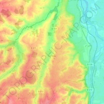
Name: Luneau topographic map, elevation, terrain.
Average elevation: 879 ft
Minimum elevation: 748 ft
Maximum elevation: 1,004 ft
Other topographic maps
Click on a map to view its topography, its elevation and its terrain.
Montluçon
Frankreich > Auvergne-Rhone-Alpen > Allier > Montluçon
Montluçon, Allier, Auvergne-Rhone-Alpen, Metropolitanes Frankreich, 03100, Frankreich
Average elevation: 840 ft
Étang de Mont
Frankreich > Auvergne-Rhone-Alpen > Allier > Beaulon
Étang de Mont, Beaulon, Moulins, Allier, Auvergne-Rhone-Alpen, Metropolitanes Frankreich, 03230, Frankreich
Average elevation: 751 ft