
Fuzeta topographic map
Interactive map
Click on the map to display elevation.
About this map
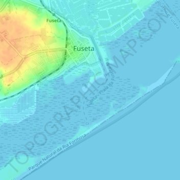
Name: Fuzeta topographic map, elevation, terrain.
Location: Fuzeta, Moncarapacho e Fuseta, Olhão, Faro, Algarve, Portugal (37.03941 -7.75361 37.05843 -7.73836)
Average elevation: 16 ft
Minimum elevation: -7 ft
Maximum elevation: 112 ft
Other topographic maps
Click on a map to view its topography, its elevation and its terrain.
Ilha da Armona
Portugal > Algarve > Moncarapacho e Fuseta
Ilha da Armona, Moncarapacho e Fuseta, Olhão, Faro, Algarve, Portugal
Average elevation: 20 ft
Moncarapacho
Portugal > Algarve > Moncarapacho e Fuseta
Moncarapacho, Moncarapacho e Fuseta, Olhão, Faro, Algarve, Portugal
Average elevation: 197 ft
Bias do Sul
Portugal > Algarve > Moncarapacho e Fuseta > Bias do Sul
Bias do Sul, Moncarapacho, Moncarapacho e Fuseta, Olhão, Faro, Algarve, 8700-129, Portugal
Average elevation: 52 ft
Ribeira de Fornalha
Portugal > Algarve > Moncarapacho e Fuseta
Ribeira de Fornalha, Moncarapacho e Fuseta, Olhão, Faro, Algarve, 8700-069, Portugal
Average elevation: 417 ft
Ribeira de Quatrim
Portugal > Algarve > Moncarapacho e Fuseta
Ribeira de Quatrim, Moncarapacho e Fuseta, Olhão, Faro, Algarve, 8700072, Portugal
Average elevation: 354 ft