
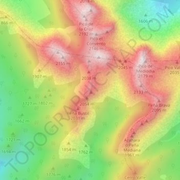
La Graya topographic map
Interactive map
Click on the map to display elevation.
About this map
Name: La Graya topographic map, elevation, terrain.
Average elevation: 5,981 ft
Minimum elevation: 4,754 ft
Maximum elevation: 7,106 ft
Other topographic maps
Click on a map to view its topography, its elevation and its terrain.
San Isidro
España > Castilla y León > Puebla de Lillo
San Isidro, Puebla de Lillo, León, Castilla y León, España
Average elevation: 5,249 ft
Isoba
España > Castilla y León > Puebla de Lillo
Isoba, Puebla de Lillo, León, Castilla y León, España
Average elevation: 5,010 ft
Las Lomas
España > Castilla y León > Puebla de Lillo
Las Lomas, Puebla de Lillo, Boñar, Castilla y León, 24855, España
Average elevation: 4,652 ft