
Sidi Boutouchent topographic map
Interactive map
Click on the map to display elevation.
About this map
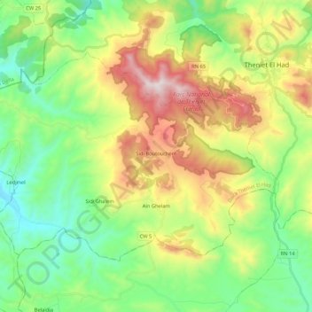
Name: Sidi Boutouchent topographic map, elevation, terrain.
Location: Sidi Boutouchent, Daïra Theniet El Had, Tissemsilt, Algérie (35.76632 1.82114 35.88106 2.03214)
Average elevation: 3,533 ft
Minimum elevation: 2,274 ft
Maximum elevation: 5,833 ft