
Conca Verde topographic map
Interactive map
Click on the map to display elevation.
About this map
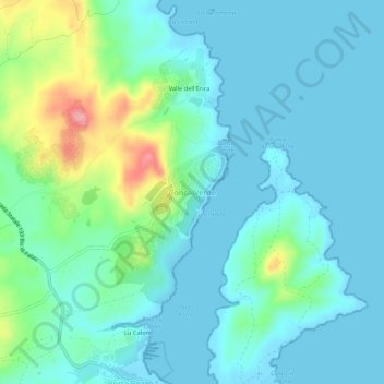
Name: Conca Verde topographic map, elevation, terrain.
Location: Conca Verde, Sassari, Sardegna, Italia (41.19389 9.25661 41.23389 9.29661)
Average elevation: 79 ft
Minimum elevation: -3 ft
Maximum elevation: 390 ft
Other topographic maps
Click on a map to view its topography, its elevation and its terrain.
Culuccia
Italia > Sardegna > Conca Verde
Culuccia, Conca Verde, Santa Teresa Gallura, Gallura Nord-Est Sardegna, Sardegna, Italia
Average elevation: 36 ft