
Thank you for supporting this site ❤️
Make a donation
Make a donation
Gear up for your next adventure:
As an Amazon Associate, this site earns from qualifying purchases at no extra cost to you.
Caimitillo topographic map
Click on the map to display elevation.
Thank you for supporting this site ❤️
Make a donation
Make a donation
Gear up for your next adventure:
As an Amazon Associate, this site earns from qualifying purchases at no extra cost to you.
About this map
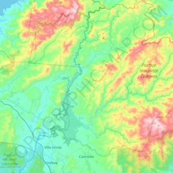
Name: Caimitillo topographic map, elevation, terrain.
Location: Caimitillo, Distrito Panamá, Panamá, Panama (9.12501 -79.61695 9.50122 -79.24724)
Average elevation: 935 ft
Minimum elevation: 0 ft
Maximum elevation: 3,278 ft
Thank you for supporting this site ❤️
Make a donation
Make a donation
Gear up for your next adventure:
As an Amazon Associate, this site earns from qualifying purchases at no extra cost to you.