
Thank you for supporting this site ❤️
Make a donation
Make a donation
Gear up for your next adventure:
As an Amazon Associate, this site earns from qualifying purchases at no extra cost to you.
Achacachi topographic map
Click on the map to display elevation.
Thank you for supporting this site ❤️
Make a donation
Make a donation
Gear up for your next adventure:
As an Amazon Associate, this site earns from qualifying purchases at no extra cost to you.
Achacachi
Achacachi is at an elevation of 3,854 m or 12.647 feet amsl on the Achacachi peninsula on the eastern shores of Lake Titicaca, 96 km (60 mi) northwest of the capital La Paz.
Thank you for supporting this site ❤️
Make a donation
Make a donation
Gear up for your next adventure:
As an Amazon Associate, this site earns from qualifying purchases at no extra cost to you.
About this map
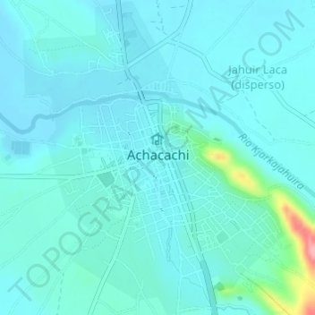
Name: Achacachi topographic map, elevation, terrain.
Average elevation: 12,595 ft
Minimum elevation: 12,543 ft
Maximum elevation: 12,933 ft
Thank you for supporting this site ❤️
Make a donation
Make a donation
Gear up for your next adventure:
As an Amazon Associate, this site earns from qualifying purchases at no extra cost to you.