
Ohuka topographic map
Interactive map
Click on the map to display elevation.
About this map
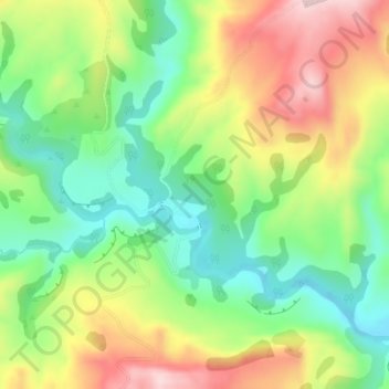
Name: Ohuka topographic map, elevation, terrain.
Location: Ohuka, Wairoa District, Hawke's Bay, 4195, New Zealand (-38.82523 177.28710 -38.80523 177.30710)
Average elevation: 781 ft
Minimum elevation: 384 ft
Maximum elevation: 1,319 ft
Other topographic maps
Click on a map to view its topography, its elevation and its terrain.
Wairoa
New Zealand > Hawke's Bay > Wairoa District
Wairoa, Wairoa District, Hawke's Bay, 4108, New Zealand
Average elevation: 75 ft
Nūhaka
New Zealand > Hawke's Bay > Wairoa District
Nūhaka, Wairoa District, Hawke's Bay, 4165, New Zealand
Average elevation: 102 ft
Tahaenui River
New Zealand > Hawke's Bay > Wairoa District
Tahaenui River, Wairoa District, Hawke's Bay, 4165, New Zealand
Average elevation: 246 ft
Mahia Beach
New Zealand > Hawke's Bay > Wairoa District > Mahia Beach
Mahia Beach, Wairoa District, Hawke's Bay, 4198, New Zealand
Average elevation: 121 ft
Lake Waikaremoana
New Zealand > Hawke's Bay > Wairoa District
Lake Waikaremoana, Wairoa District, Hawke's Bay, New Zealand
Average elevation: 2,316 ft