
Make a donation
Gear up for your next adventure:
As an Amazon Associate, this site earns from qualifying purchases at no extra cost to you.
Hardeeville topographic map
Click on the map to display elevation.
Make a donation
Gear up for your next adventure:
As an Amazon Associate, this site earns from qualifying purchases at no extra cost to you.
Hardeeville
The city is located on the Atlantic coastal plain, with very few variations in elevation. The average elevation of the city is approximately 20 feet (6.1 m) above mean sea level. Most of Hardeeville is located within Jasper County, though a small portion of the city crosses into Beaufort County. Much of the city is bordered to the west by the Savannah National Wildlife Refuge, a large-scale nature preserve along the South Carolina and Georgia sides of the Savannah River.
Make a donation
Gear up for your next adventure:
As an Amazon Associate, this site earns from qualifying purchases at no extra cost to you.
About this map
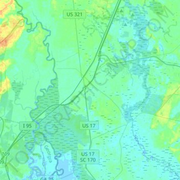
Name: Hardeeville topographic map, elevation, terrain.
Average elevation: 16 ft
Minimum elevation: -13 ft
Maximum elevation: 89 ft
Jasper County trails, hiking, mountain biking, running and outdoor activities
Make a donation
Gear up for your next adventure:
As an Amazon Associate, this site earns from qualifying purchases at no extra cost to you.
Other topographic maps
Click on a map to view its topography, its elevation and its terrain.
Make a donation
Gear up for your next adventure:
As an Amazon Associate, this site earns from qualifying purchases at no extra cost to you.
Latitude Margaritaville
United States > South Carolina > Jasper County > Hardeeville
Average elevation: 13 ft