
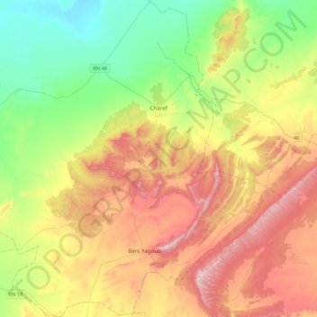
Charef topographic map
Interactive map
Click on the map to display elevation.
About this map
Name: Charef topographic map, elevation, terrain.
Location: Charef, Daïra Charef, Djelfa, 17015, Algérie (34.39478 2.57451 34.74655 2.87920)
Average elevation: 3,878 ft
Minimum elevation: 2,904 ft
Maximum elevation: 5,299 ft
34° 37′ 5″ Nord, 2° 48′ 4″ Est Superficie de Charef 59 055 hectares 590,55 km² Altitude de Charef 1 173 m Climat de Charef Climat semi-aride sec et froid (Classification de Köppen: BSk)
Other topographic maps
Click on a map to view its topography, its elevation and its terrain.
El Guedid
Algérie > Djelfa > Daïra Charef > El Guedid
El Guedid, Daïra Charef, Djelfa, Algérie
Average elevation: 3,320 ft
Beni Yagoub
Algérie > Djelfa > Daïra Charef
Beni Yagoub, Daïra Charef, Djelfa, Algérie
Average elevation: 4,285 ft