
Cochem topographic map
Interactive map
Click on the map to display elevation.
About this map
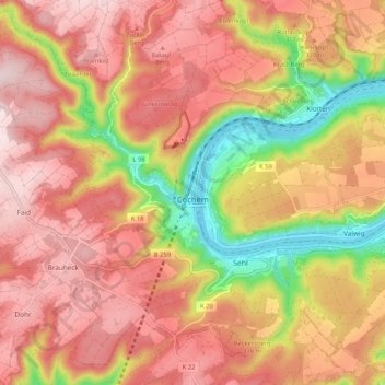
Name: Cochem topographic map, elevation, terrain.
Location: Cochem, Landkreis Cochem-Zell, Rhénanie-Palatinat, Allemagne (50.11968 7.10805 50.17937 7.21255)
Average elevation: 938 ft
Minimum elevation: 256 ft
Maximum elevation: 1,375 ft
Other topographic maps
Click on a map to view its topography, its elevation and its terrain.
Zell (Mosel)
Allemagne > Rhénanie-Palatinat > Landkreis Cochem-Zell
Zell (Mosel), Landkreis Cochem-Zell, Rhénanie-Palatinat, 56856, Allemagne
Average elevation: 942 ft
Beilstein
Allemagne > Rhénanie-Palatinat > Landkreis Cochem-Zell > Beilstein
Beilstein, Cochem, Landkreis Cochem-Zell, Rhénanie-Palatinat, Allemagne
Average elevation: 784 ft