
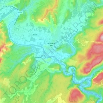
Vallon-Pont-d'Arc topographic map
Interactive map
Click on the map to display elevation.
About this map
Name: Vallon-Pont-d'Arc topographic map, elevation, terrain.
Average elevation: 627 ft
Minimum elevation: 223 ft
Maximum elevation: 1,562 ft
Other topographic maps
Click on a map to view its topography, its elevation and its terrain.
Sanilhac
Frankreich > Auvergne-Rhone-Alpen > Ardèche
Sanilhac, Largentière, Ardèche, Auvergne-Rhone-Alpen, Metropolitanes Frankreich, 07110, Frankreich
Average elevation: 1,237 ft
Pradon
Frankreich > Auvergne-Rhone-Alpen > Ardèche > Montselgues
Pradon, Montselgues, Largentière, Ardèche, Auvergne-Rhone-Alpen, Metropolitanes Frankreich, 07140, Frankreich
Average elevation: 3,232 ft
Vals-les-Bains
Frankreich > Auvergne-Rhone-Alpen > Ardèche
Vals-les-Bains, Largentière, Ardèche, Auvergne-Rhone-Alpen, Metropolitanes Frankreich, 07600, Frankreich
Average elevation: 1,266 ft
Ardèche
Frankreich > Auvergne-Rhone-Alpen > Ardèche
Ardèche, Auvergne-Rhone-Alpen, Metropolitanes Frankreich, Frankreich
Average elevation: 2,096 ft