
Tecopa topographic map
Click on the map to display elevation.
Tecopa
Tecopa (formerly Brownsville) is a census-designated place (CDP) in the Mojave Desert, in Inyo County, California, United States. Tecopa is located 9 miles (14 km) south-southeast of Shoshone, at an elevation of 1,339 feet (408 m). The population was 150 at the 2010 census, up from 99 at the 2000 census.
About this map
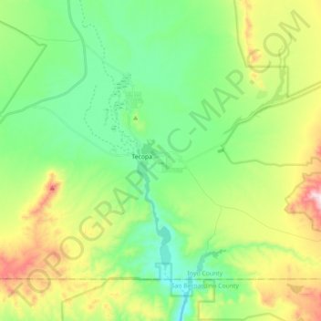
Name: Tecopa topographic map, elevation, terrain.
Average elevation: 1,667 ft
Minimum elevation: 1,010 ft
Maximum elevation: 3,038 ft
CAL Fire San Bernardino Unit trails, hiking, mountain biking, running and outdoor activities