
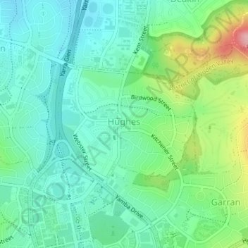
Hughes topographic map
Interactive map
Click on the map to display elevation.
About this map
Name: Hughes topographic map, elevation, terrain.
Average elevation: 1,985 ft
Minimum elevation: 1,854 ft
Maximum elevation: 2,326 ft
Other topographic maps
Click on a map to view its topography, its elevation and its terrain.
Curtin
Australia > District of Woden Valley
Curtin, District of Woden Valley, Australian Capital Territory, Australia
Average elevation: 1,919 ft
Farrer
Australia > District of Woden Valley
Farrer, District of Woden Valley, Australian Capital Territory, Australia
Average elevation: 2,208 ft
Pearce
Australia > District of Woden Valley
Pearce, District of Woden Valley, Australian Capital Territory, Australia
Average elevation: 2,133 ft
Isaacs
Australia > District of Woden Valley
Isaacs, District of Woden Valley, Australian Capital Territory, Australia
Average elevation: 2,267 ft
Garran
Australia > District of Woden Valley
Garran, District of Woden Valley, Australian Capital Territory, Australia
Average elevation: 2,100 ft
Mawson
Australia > District of Woden Valley
Mawson, District of Woden Valley, Australian Capital Territory, 2607, Australia
Average elevation: 2,100 ft