
Make a donation
Gear up for your next adventure:
As an Amazon Associate, this site earns from qualifying purchases at no extra cost to you.
Tolmezzo topographic map
Click on the map to display elevation.
Make a donation
Gear up for your next adventure:
As an Amazon Associate, this site earns from qualifying purchases at no extra cost to you.
Tolmezzo
Tolmezzo is located at the foot of the Strabut Mountain, between the Tagliamento River and the Bût stream. Nearby is the Mount Amariana, elevation 1,906 metres (6,253 ft). The commune also includes the five frazioni (boroughs) of Cadunea (Friulian: Cjadugnee), Caneva (Cjanive), Casanova (Cjasegnove), Fusea (Fusee), Illegio (Dieç), Imponzo (Dimponç).
Make a donation
Gear up for your next adventure:
As an Amazon Associate, this site earns from qualifying purchases at no extra cost to you.
About this map
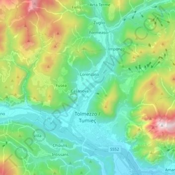
Name: Tolmezzo topographic map, elevation, terrain.
Location: Tolmezzo, Udine, Friuli – Venezia Giulia, 33028, Italy (46.38141 12.96018 46.46437 13.11146)
Average elevation: 2,385 ft
Minimum elevation: 810 ft
Maximum elevation: 6,142 ft
Make a donation
Gear up for your next adventure:
As an Amazon Associate, this site earns from qualifying purchases at no extra cost to you.
Other topographic maps
Click on a map to view its topography, its elevation and its terrain.
Tribil Superiore / Gorenji Tarbij
Italy > Friuli – Venezia Giulia > Udine > Stregna
Average elevation: 1,640 ft
Make a donation
Gear up for your next adventure:
As an Amazon Associate, this site earns from qualifying purchases at no extra cost to you.
Make a donation
Gear up for your next adventure:
As an Amazon Associate, this site earns from qualifying purchases at no extra cost to you.
Timau / Tischlbong
Italy > Friuli – Venezia Giulia > Udine > Paluzza / Paluce / Palutsch
Average elevation: 4,288 ft
Sauris di Sopra / Plozn / Sauris Disore
Italy > Friuli – Venezia Giulia > Udine
Average elevation: 4,820 ft
Make a donation
Gear up for your next adventure:
As an Amazon Associate, this site earns from qualifying purchases at no extra cost to you.