
秀山县 topographic map
Interactive map
Click on the map to display elevation.
About this map
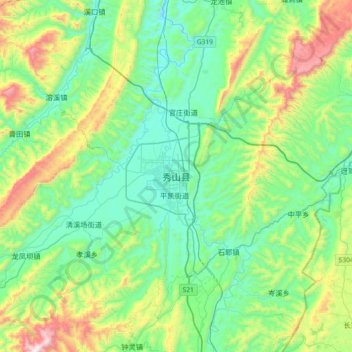
Name: 秀山县 topographic map, elevation, terrain.
Location: 秀山县, 中和街道, 秀山土家族苗族自治县, 重庆市, 中国 (28.29025 108.84271 28.61025 109.16271)
Average elevation: 1,909 ft
Minimum elevation: 965 ft
Maximum elevation: 4,659 ft
秀山土家族苗族自治县位于武陵山脉二级隆起带南段,四川盆地东南缘的外侧,地处川东南褶皱带。县内河流切割强烈,地表起伏大,主要地形为山地丘陵,中部有盆地平坝。