
Saint-Martin topographic map
Interactive map
Click on the map to display elevation.
About this map
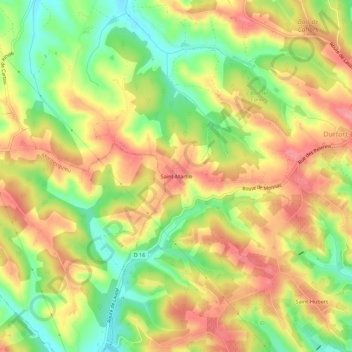
Name: Saint-Martin topographic map, elevation, terrain.
Average elevation: 505 ft
Minimum elevation: 335 ft
Maximum elevation: 646 ft
Other topographic maps
Click on a map to view its topography, its elevation and its terrain.
Saint-Paul
France > Occitanie > Tarn-et-Garonne > Durfort-Lacapelette
Saint-Paul, Durfort-Lacapelette, Castelsarrasin, Tarn-et-Garonne, Occitanie, France métropolitaine, 82390, France
Average elevation: 515 ft