
Make a donation
Gear up for your next adventure:
As an Amazon Associate, this site earns from qualifying purchases at no extra cost to you.
Navarrenx topographic map
Click on the map to display elevation.
Make a donation
Gear up for your next adventure:
As an Amazon Associate, this site earns from qualifying purchases at no extra cost to you.
About this map
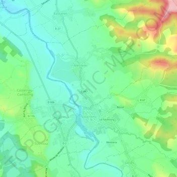
Name: Navarrenx topographic map, elevation, terrain.
Average elevation: 476 ft
Minimum elevation: 308 ft
Maximum elevation: 869 ft
Make a donation
Gear up for your next adventure:
As an Amazon Associate, this site earns from qualifying purchases at no extra cost to you.
Other topographic maps
Click on a map to view its topography, its elevation and its terrain.
Urguri
France > Nouvelle-Aquitaine > Pyrénées-Atlantiques > Saint-Pée-sur-Nivelle
Average elevation: 213 ft
Make a donation
Gear up for your next adventure:
As an Amazon Associate, this site earns from qualifying purchases at no extra cost to you.
Ibarrun
France > Nouvelle-Aquitaine > Pyrénées-Atlantiques > Saint-Pée-sur-Nivelle
Average elevation: 223 ft
Alhahiri
France > Nouvelle-Aquitaine > Pyrénées-Atlantiques > Saint-Martin-d'Arrossa
Average elevation: 801 ft
Make a donation
Gear up for your next adventure:
As an Amazon Associate, this site earns from qualifying purchases at no extra cost to you.
Make a donation
Gear up for your next adventure:
As an Amazon Associate, this site earns from qualifying purchases at no extra cost to you.