Geolocate

Athirapally Falls topographic map

Interactive map

Click on the map to display elevation.

About this map

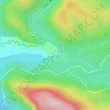
Name: Athirapally Falls topographic map, elevation, terrain.

Location: Athirapally Falls, Aluva, Ernakulam district, Kerala, India (10.28480 76.56834 10.28724 76.57408)

Average elevation: 646 ft

Minimum elevation: 164 ft

Maximum elevation: 1,394 ft

Other topographic maps

Click on a map to view its topography, its elevation and its terrain.

Nedumbassery

India > Kerala > Aluva

Nedumbassery, Aluva, Ernakulam District, Kerala, 683111, India

Average elevation: 36 ft

Kalady

India > Kerala > Aluva

Kalady, Aluva, Ernakulam district, Kerala, 683550, India

Average elevation: 46 ft

Angamaly

India > Kerala > Aluva > Angamaly

Angamaly, Aluva, Ernakulam district, Kerala, 683572, India

Average elevation: 49 ft

Aluva

India > Kerala > Aluva

Aluva, Ernakulam District, Kerala, 683101, India

Average elevation: 36 ft