
Make a donation
Gear up for your next adventure:
As an Amazon Associate, this site earns from qualifying purchases at no extra cost to you.
La Fortuna topographic map
Click on the map to display elevation.
Make a donation
Gear up for your next adventure:
As an Amazon Associate, this site earns from qualifying purchases at no extra cost to you.
About this map
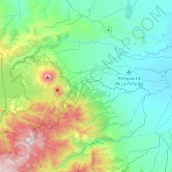
Name: La Fortuna topographic map, elevation, terrain.
Location: La Fortuna, San Carlos, Alajuela Province, 21007, Costa Rica (10.37648 -84.77346 10.52245 -84.51048)
Average elevation: 1,568 ft
Minimum elevation: 200 ft
Maximum elevation: 5,840 ft
Make a donation
Gear up for your next adventure:
As an Amazon Associate, this site earns from qualifying purchases at no extra cost to you.
Other topographic maps
Click on a map to view its topography, its elevation and its terrain.
Arenal Volcano
Costa Rica > Alajuela Province > San Carlos > La Fortuna
Arenal has several eruptive vents. Chato is a dormant stratovolcanic cone. It is believed that Chato first erupted 38,000 years ago during the Pleistocene period and last erupted about 3,500 years ago. Chatito is a lava dome with an elevation of 1,100 metres (3,609 ft). Espina is another lava dome.
Average elevation: 3,327 ft