
Ciruelos topographic map
Interactive map
Click on the map to display elevation.
About this map
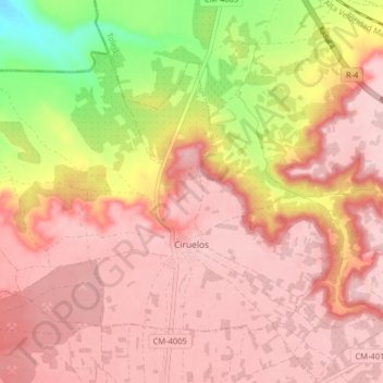
Name: Ciruelos topographic map, elevation, terrain.
Location: Ciruelos, Mesa de Ocaña, Toledo, Castilla-La Mancha, España (39.92441 -3.66639 39.96919 -3.58634)
Average elevation: 2,162 ft
Minimum elevation: 1,736 ft
Maximum elevation: 2,356 ft