
Make a donation
Gear up for your next adventure:
As an Amazon Associate, this site earns from qualifying purchases at no extra cost to you.
Acapulco topographic map
Click on the map to display elevation.
Make a donation
Gear up for your next adventure:
As an Amazon Associate, this site earns from qualifying purchases at no extra cost to you.
Acapulco
The city, located on the Pacific coast of Mexico in the state of Guerrero, is classified as one of the state's seven regions, dividing the rest of the Guerrero coast into the Costa Grande and the Costa Chica. Forty percent of the municipality is mountainous terrain; another forty percent is semi-flat; and the other twenty percent is flat. Elevation varies from sea level to 1,699 metres (5,574 feet). The highest peaks are Potrero, San Nicolas, and Alto Camarón. One major river runs through the municipality, the Papagayo, along with a number of arroyos (streams). There are also two small lagoons, Tres Palos and Coyuca, along with a number of thermal springs.
Make a donation
Gear up for your next adventure:
As an Amazon Associate, this site earns from qualifying purchases at no extra cost to you.
About this map
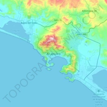
Name: Acapulco topographic map, elevation, terrain.
Location: Acapulco, Acapulco de Juárez, Guerrero, 39300, Mexico (16.70805 -100.05402 17.02805 -99.73402)
Average elevation: 325 ft
Minimum elevation: -7 ft
Maximum elevation: 3,058 ft
Make a donation
Gear up for your next adventure:
As an Amazon Associate, this site earns from qualifying purchases at no extra cost to you.
Other topographic maps
Click on a map to view its topography, its elevation and its terrain.
Centro Internacional Acapulco
Mexico > Guerrero > Acapulco de Juárez > Acapulco
Average elevation: 223 ft