
Make a donation
Gear up for your next adventure:
As an Amazon Associate, this site earns from qualifying purchases at no extra cost to you.
Itatiaia topographic map
Click on the map to display elevation.
Make a donation
Gear up for your next adventure:
As an Amazon Associate, this site earns from qualifying purchases at no extra cost to you.
Itatiaia
Itatiaia (Portuguese pronunciation: [itɐtʃiˈaj.jɐ]) is a Brazilian municipality of the state of Rio de Janeiro. It is located at an altitude of 695 m (2,280 ft). Its population was 32,064 in 2020 and its area is 224.96 km2 (86.86 sq mi).
Make a donation
Gear up for your next adventure:
As an Amazon Associate, this site earns from qualifying purchases at no extra cost to you.
About this map
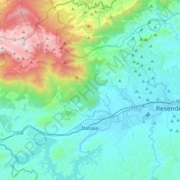
Name: Itatiaia topographic map, elevation, terrain.
Average elevation: 2,848 ft
Minimum elevation: 1,283 ft
Maximum elevation: 9,062 ft
Make a donation
Gear up for your next adventure:
As an Amazon Associate, this site earns from qualifying purchases at no extra cost to you.
Other topographic maps
Click on a map to view its topography, its elevation and its terrain.
Petrópolis
Brazil > Rio de Janeiro > Região Metropolitana do Rio de Janeiro > Petrópolis
Average elevation: 2,241 ft