
Thank you for supporting this site ❤️
Make a donation
Make a donation
Gear up for your next adventure:
As an Amazon Associate, this site earns from qualifying purchases at no extra cost to you.
Tacna topographic map
Click on the map to display elevation.
Thank you for supporting this site ❤️
Make a donation
Make a donation
Gear up for your next adventure:
As an Amazon Associate, this site earns from qualifying purchases at no extra cost to you.
About this map
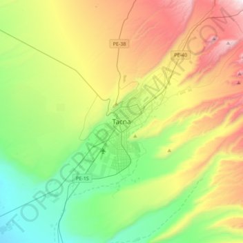
Name: Tacna topographic map, elevation, terrain.
Location: Tacna, Province of Tacna, Tacna, 23001, Peru (-18.17385 -70.41116 -17.85385 -70.09116)
Average elevation: 2,411 ft
Minimum elevation: 404 ft
Maximum elevation: 5,988 ft
Thank you for supporting this site ❤️
Make a donation
Make a donation
Gear up for your next adventure:
As an Amazon Associate, this site earns from qualifying purchases at no extra cost to you.