
Make a donation
Gear up for your next adventure:
As an Amazon Associate, this site earns from qualifying purchases at no extra cost to you.
Santa Rosa topographic map
Click on the map to display elevation.
Make a donation
Gear up for your next adventure:
As an Amazon Associate, this site earns from qualifying purchases at no extra cost to you.
Santa Rosa
The town occupies part of a centripetal basin having their base in Don Tomás Lagoon, where rainwater drains from the surrounding area. The floor area lies west of it, in hilly terrain where the highest elevations are in the east, with two small plateaus located 200 meters. This high turnover is also observed north, with heights up to 195 meters. From here the terrain descends to the west and south, with slopes that are steep in some areas, since more than 3%. The southwest sector is lower and less undulating area, descending to 167 masl.
Make a donation
Gear up for your next adventure:
As an Amazon Associate, this site earns from qualifying purchases at no extra cost to you.
About this map
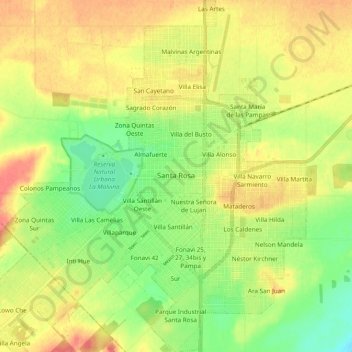
Name: Santa Rosa topographic map, elevation, terrain.
Average elevation: 607 ft
Minimum elevation: 495 ft
Maximum elevation: 715 ft
Make a donation
Gear up for your next adventure:
As an Amazon Associate, this site earns from qualifying purchases at no extra cost to you.
Other topographic maps
Click on a map to view its topography, its elevation and its terrain.