
Make a donation
Gear up for your next adventure:
As an Amazon Associate, this site earns from qualifying purchases at no extra cost to you.
Minden topographic map
Click on the map to display elevation.
Make a donation
Gear up for your next adventure:
As an Amazon Associate, this site earns from qualifying purchases at no extra cost to you.
Minden
The Weser leaves the Minden area at its lowest part in the quarter of Leteln, at 40 metres (131 feet), while the highest part is the top of Häverstädter Berg with 272 metres (892 feet), at the edge of the Wiehen Hills in the quarter of Haddenhausen. The altitude of the town is given officially as 42.2 metres (138.5 feet), based on the elevation of the town hall.
Make a donation
Gear up for your next adventure:
As an Amazon Associate, this site earns from qualifying purchases at no extra cost to you.
About this map
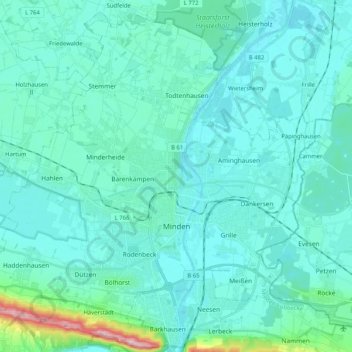
Name: Minden topographic map, elevation, terrain.
Location: Minden, Kreis Minden-Lübbecke, North Rhine-Westphalia, Germany (52.24706 8.79206 52.36487 8.99831)
Average elevation: 197 ft
Minimum elevation: 115 ft
Maximum elevation: 860 ft
Make a donation
Gear up for your next adventure:
As an Amazon Associate, this site earns from qualifying purchases at no extra cost to you.
Other topographic maps
Click on a map to view its topography, its elevation and its terrain.
Reineberg
Germany > North Rhine-Westphalia > Kreis Minden-Lübbecke > Lübbecke
The Reineberg is a hill on the Wiehen ridge, south of the town of Lübbecke. With a height of 275.9 m above sea level it is, from a topographical point of view, not a particularly impressive eminence in this part of the Wiehen Hills, because, in the immediate vicinity are considerably higher summits, such as…
Average elevation: 594 ft
Heimsen
Germany > North Rhine-Westphalia > Kreis Minden-Lübbecke > Petershagen
Average elevation: 135 ft
Hüllhorst
Germany > North Rhine-Westphalia > Kreis Minden-Lübbecke > Hüllhorst > Hüllhorst
Average elevation: 394 ft
Lübbecke
Germany > North Rhine-Westphalia > Kreis Minden-Lübbecke > Lübbecke > Lübbecke
Average elevation: 361 ft
Make a donation
Gear up for your next adventure:
As an Amazon Associate, this site earns from qualifying purchases at no extra cost to you.