
Thank you for supporting this site ❤️
Make a donation
Make a donation
Gear up for your next adventure:
As an Amazon Associate, this site earns from qualifying purchases at no extra cost to you.
Alaşehir topographic map
Click on the map to display elevation.
Thank you for supporting this site ❤️
Make a donation
Make a donation
Gear up for your next adventure:
As an Amazon Associate, this site earns from qualifying purchases at no extra cost to you.
About this map
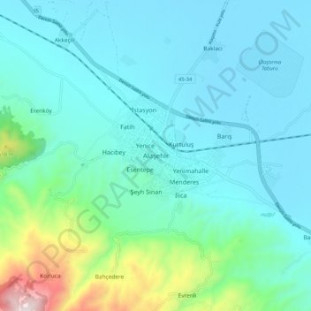
Name: Alaşehir topographic map, elevation, terrain.
Location: Alaşehir, Manisa, Aegean Region, 45600, Turkey (38.31075 28.47658 38.39075 28.55658)
Average elevation: 981 ft
Minimum elevation: 463 ft
Maximum elevation: 3,556 ft
Thank you for supporting this site ❤️
Make a donation
Make a donation
Gear up for your next adventure:
As an Amazon Associate, this site earns from qualifying purchases at no extra cost to you.