Geolocate

Laredo topographic map

Click on the map to display elevation.

About this map

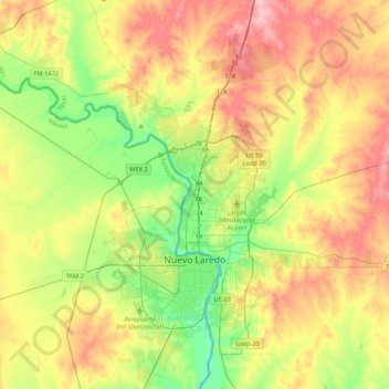
Name: Laredo topographic map, elevation, terrain.

Location: Laredo, Webb County, Texas, United States (27.36649 -99.75031 27.74441 -99.33103)

Average elevation: 525 ft

Minimum elevation: 341 ft

Maximum elevation: 758 ft

Webb County trails, hiking, mountain biking, running and outdoor activities

Other topographic maps

Click on a map to view its topography, its elevation and its terrain.

Briscoe Ranch Dam

United States > Texas > Webb County

Average elevation: 577 ft

Osprey Hill

United States > Texas > Webb County > Laredo

Average elevation: 453 ft

Biel Lake

United States > Texas > Webb County

Average elevation: 381 ft

Las Tiendas

United States > Texas > Webb County

Average elevation: 587 ft

Biel Lake

United States > Texas > Webb County

Average elevation: 381 ft

Laredo

United States > Texas > Webb County

Average elevation: 525 ft

Gear up for your next adventure:

🏫Relief Map Kits - Hands-on tools for teaching landforms and elevation
👓Polarized Sunglasses - Outdoor sunglasses for glare reduction
📱Heavy-Duty Phone Cases - Drop-proof and waterproof protection for outdoor navigation
📶Satellite Messenger - Communication device off‑grid
🪵Folding Camp Saw - Compact saw for wood and campsite work

As an Amazon Associate, this site earns from qualifying purchases at no extra cost to you.