
Bawley Point topographic map
Interactive map
Click on the map to display elevation.
About this map
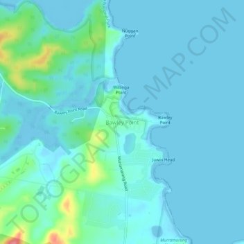
Name: Bawley Point topographic map, elevation, terrain.
Average elevation: 36 ft
Minimum elevation: -16 ft
Maximum elevation: 279 ft
Other topographic maps
Click on a map to view its topography, its elevation and its terrain.
Murramarang Point
Australia > New South Wales > Bawley Point
Murramarang Point, Bawley Point, Shoalhaven City Council, New South Wales, 2539, Australia
Average elevation: 13 ft
Meroo National Park
Australia > New South Wales > Bawley Point
Meroo National Park, Meroo Point Road, Termeil, Bawley Point, Shoalhaven City Council, New South Wales, 2539, Australia
Average elevation: 210 ft