
Parque Fernando Peñalver topographic map
Interactive map
Click on the map to display elevation.
About this map
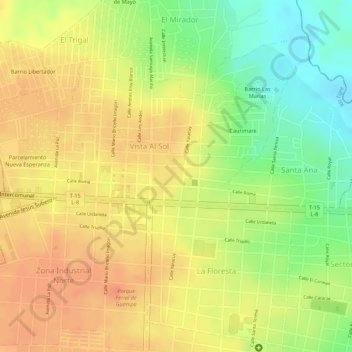
Name: Parque Fernando Peñalver topographic map, elevation, terrain.
Average elevation: 853 ft
Minimum elevation: 748 ft
Maximum elevation: 912 ft
Other topographic maps
Click on a map to view its topography, its elevation and its terrain.
San José de Guanipa
Venezuela > Estado Anzoátegui > San José de Guanipa
San José de Guanipa, Parroquia San José de Guanipa, Municipio Guanipa, Estado Anzoátegui, Región Nororiental, 6054, Venezuela
Average elevation: 840 ft