
Rances topographic map
Interactive map
Click on the map to display elevation.
About this map
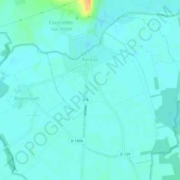
Name: Rances topographic map, elevation, terrain.
Average elevation: 381 ft
Minimum elevation: 361 ft
Maximum elevation: 476 ft
Other topographic maps
Click on a map to view its topography, its elevation and its terrain.
Les Croisettes
France > Grand Est > Aube > Dienville
Les Croisettes, Dienville, Bar-sur-Aube, Aube, Grand Est, France métropolitaine, 10500, France
Average elevation: 446 ft
Clairvaux
France > Grand Est > Aube > Ville-sous-la-Ferté
Clairvaux, Ville-sous-la-Ferté, Bar-sur-Aube, Aube, Grand Est, France métropolitaine, 10310, France
Average elevation: 781 ft
Bas du Village
France > Grand Est > Aube > Le Chêne
Bas du Village, Le Chêne, Troyes, Aube, Grand Est, France métropolitaine, 10700, France
Average elevation: 322 ft
Ervy-le-Châtel
Ervy-le-Châtel, Troyes, Aube, Grand Est, France métropolitaine, 10130, France
Average elevation: 456 ft
Saint-Nicolas-la-Chapelle
France > Grand Est > Aube > Saint-Nicolas-la-Chapelle
Saint-Nicolas-la-Chapelle, Nogent-sur-Seine, Aube, Grand Est, France métropolitaine, 10400, France
Average elevation: 299 ft