
Thank you for supporting this site ❤️
Make a donation
Make a donation
Gear up for your next adventure:
As an Amazon Associate, this site earns from qualifying purchases at no extra cost to you.
Homburg topographic map
Click on the map to display elevation.
Thank you for supporting this site ❤️
Make a donation
Make a donation
Gear up for your next adventure:
As an Amazon Associate, this site earns from qualifying purchases at no extra cost to you.
About this map
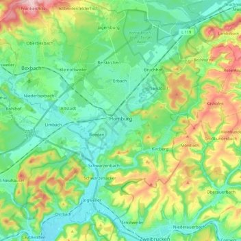
Name: Homburg topographic map, elevation, terrain.
Location: Homburg, Saarpfalz-Kreis, Saarland, 66424, Germany (49.24742 7.27372 49.38637 7.40483)
Average elevation: 932 ft
Minimum elevation: 702 ft
Maximum elevation: 1,467 ft
Thank you for supporting this site ❤️
Make a donation
Make a donation
Gear up for your next adventure:
As an Amazon Associate, this site earns from qualifying purchases at no extra cost to you.