Geolocate

Grasmere topographic map

Click on the map to display elevation.

Grasmere

The lake is 1680 yd (1540 m) long and 700 yd (640 m) wide, covering an area of 0.24 mi² (0.62 km²). It has a maximum depth of 70 ft (21m) and an elevation above sea level of 208 ft (62 m). The lake is both fed and drained by the River Rothay, which flows through the village before entering the lake, and then exits downstream into nearby Rydal Water, beyond which it continues into Windermere.

About this map

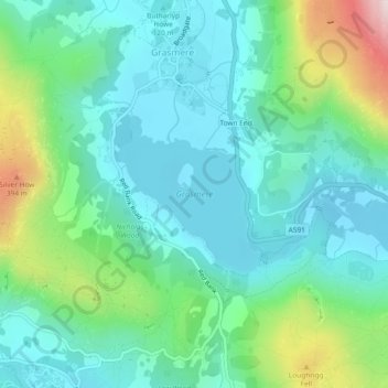
Name: Grasmere topographic map, elevation, terrain.

Location: Grasmere, Lakes, Grasmere, South Lakeland, Cumbria, North West England, England, United Kingdom (54.44391 -3.03094 54.45507 -3.01396)

Average elevation: 531 ft

Minimum elevation: 177 ft

Maximum elevation: 1,644 ft

Gear up for your next adventure:

👟Men's Trail Runners - Lightweight footwear for fast-paced exploration and light hiking
🛰️Handheld GPS Units - Professional satellite navigators for precise backcountry mapping
🪶Trail Camera - Capture wildlife on your hikes
Backpacking Tent - Lightweight and durable tent for multi‑day hikes
🔋Rechargeable Batteries - Power up your outdoor devices

As an Amazon Associate, this site earns from qualifying purchases at no extra cost to you.