
Make a donation
Gear up for your next adventure:
As an Amazon Associate, this site earns from qualifying purchases at no extra cost to you.
East Meadow topographic map
Click on the map to display elevation.
Make a donation
Gear up for your next adventure:
As an Amazon Associate, this site earns from qualifying purchases at no extra cost to you.
East Meadow
East Meadow is generally flat, and according to the United States Geological Survey and the United States Environmental Protection Agency, the elevation ranges from 32 feet (9.8 m) near its southwestern edge, to 82 feet (25 m) along Hempstead Turnpike to the north.
Make a donation
Gear up for your next adventure:
As an Amazon Associate, this site earns from qualifying purchases at no extra cost to you.
About this map
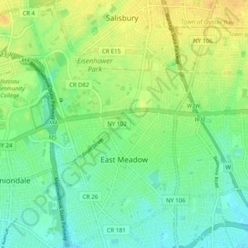
Name: East Meadow topographic map, elevation, terrain.
Average elevation: 85 ft
Minimum elevation: 46 ft
Maximum elevation: 135 ft
Nassau County trails, hiking, mountain biking, running and outdoor activities
Make a donation
Gear up for your next adventure:
As an Amazon Associate, this site earns from qualifying purchases at no extra cost to you.