
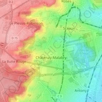
Châtenay-Malabry topographic map
Interactive map
Click on the map to display elevation.
About this map
Name: Châtenay-Malabry topographic map, elevation, terrain.
Average elevation: 364 ft
Minimum elevation: 164 ft
Maximum elevation: 587 ft
Other topographic maps
Click on a map to view its topography, its elevation and its terrain.
Clamart
Frankreich > Île-de-France > Hauts-de-Seine
Clamart, Antony, Hauts-de-Seine, Île-de-France, Metropolitanes Frankreich, 92140, Frankreich
Average elevation: 413 ft
Bagneux
Frankreich > Île-de-France > Hauts-de-Seine
Bagneux, Antony, Hauts-de-Seine, Île-de-France, Metropolitanes Frankreich, 92220, Frankreich
Average elevation: 299 ft
Nanterre
Frankreich > Île-de-France > Hauts-de-Seine
Nanterre, Arrondissement de Nanterre, Hauts-de-Seine, Île-de-France, Metropolitanes Frankreich, 92000, Frankreich
Average elevation: 148 ft
Suresnes
Frankreich > Île-de-France > Hauts-de-Seine
Suresnes, Arrondissement de Nanterre, Hauts-de-Seine, Île-de-France, Metropolitanes Frankreich, 92150, Frankreich
Average elevation: 203 ft