
Bucaramanga topographic map
Interactive map
Click on the map to display elevation.
About this map
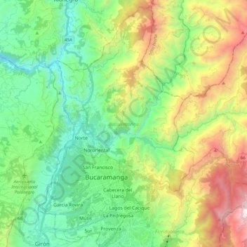
Name: Bucaramanga topographic map, elevation, terrain.
Location: Bucaramanga, Metropolitana, Santander, Colombia (7.06968 -73.16937 7.26372 -73.04906)
Average elevation: 3,924 ft
Minimum elevation: 1,391 ft
Maximum elevation: 8,776 ft
Other topographic maps
Click on a map to view its topography, its elevation and its terrain.
Parque de Los Pinos
Colombia > Santander > Bucaramanga
Parque de Los Pinos, Bucaramanga, Santander, Colombia
Average elevation: 3,419 ft