
Ossa topographic map
Interactive map
Click on the map to display elevation.
About this map
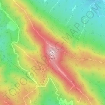
Name: Ossa topographic map, elevation, terrain.
Location: Ossa, Estremoz, Évora, 7170-120, Portugal (38.73945 -7.58402 38.73955 -7.58392)
Average elevation: 1,519 ft
Minimum elevation: 971 ft
Maximum elevation: 2,146 ft
A serra de Ossa ou serra d'Ossa é uma elevação de Portugal Continental, com 653 metros de altitude. Situa-se no Alto Alentejo, entre Estremoz e o Redondo.
Other topographic maps
Click on a map to view its topography, its elevation and its terrain.
Caldeireiros
Caldeireiros, Estremoz, Évora, 7100-032, Portugal
Average elevation: 1,503 ft
Évoramonte
Évoramonte, Estremoz, Évora, 7100-308, Portugal
Average elevation: 1,076 ft
Santa Maria
Santa Maria, Estremoz, Évora, Portugal
Average elevation: 1,102 ft
Ameixial (Santa Vitória e São Bento)
Ameixial (Santa Vitória e São Bento), Estremoz, Évora, Portugal
Average elevation: 951 ft