
De Poel topographic map
Interactive map
Click on the map to display elevation.
About this map
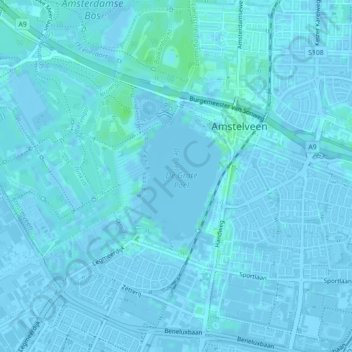
Name: De Poel topographic map, elevation, terrain.
Location: De Poel, Amstelveen, Noord-Holland, Nederland, 1187AD, Nederland (52.29470 4.83881 52.30280 4.83911)
Average elevation: 0 ft
Minimum elevation: -20 ft
Maximum elevation: 20 ft
Other topographic maps
Click on a map to view its topography, its elevation and its terrain.
Amstelveen
Nederland > Noord-Holland > Amstelveen
Amstelveen, Noord-Holland, Nederland
Average elevation: -7 ft
Amsterdamse Bos
Nederland > Noord-Holland > Amstelveen
Amsterdamse Bos, Amstelveen, Noord-Holland, Nederland
Average elevation: 0 ft