
Saint-Laurent topographic map
Interactive map
Click on the map to display elevation.
About this map
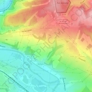
Name: Saint-Laurent topographic map, elevation, terrain.
Average elevation: 669 ft
Minimum elevation: 436 ft
Maximum elevation: 932 ft
Other topographic maps
Click on a map to view its topography, its elevation and its terrain.
Saint-Onésime
France > Grand Est > Ardennes > Donchery
Saint-Onésime, Donchery, Sedan, Ardennes, Grand Est, France métropolitaine, 08350, France
Average elevation: 646 ft
Charleville-Mézières
Charleville-Mézières, Ardennes, Grand Est, France métropolitaine, 08000, France
Average elevation: 659 ft