
Tamarack topographic map
Interactive map
Click on the map to display elevation.
About this map
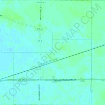
Name: Tamarack topographic map, elevation, terrain.
Location: Tamarack, Aitkin County, Minnesota, 55787, United States (46.63730 -93.14838 46.66655 -93.10616)
Average elevation: 1,270 ft
Minimum elevation: 1,260 ft
Maximum elevation: 1,286 ft
Other topographic maps
Click on a map to view its topography, its elevation and its terrain.
Hill City
United States > Minnesota > Aitkin County
Hill City, Aitkin County, Minnesota, United States
Average elevation: 1,306 ft
Palisade
United States > Minnesota > Aitkin County
Palisade, Aitkin County, Minnesota, United States
Average elevation: 1,224 ft
McGregor
United States > Minnesota > Aitkin County
McGregor, Aitkin County, Minnesota, United States
Average elevation: 1,230 ft
McGrath
United States > Minnesota > Aitkin County
McGrath, Aitkin County, Minnesota, United States
Average elevation: 1,243 ft