Geolocate

Balingasay topographic map

Click on the map to display elevation.

About this map

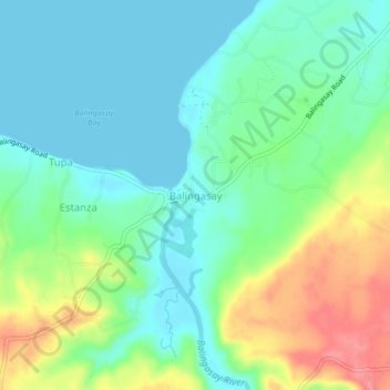
Name: Balingasay topographic map, elevation, terrain.

Location: Balingasay, Pangasinan, Ilocos Region, 2406, Philippines (16.33715 119.83773 16.37715 119.87773)

Average elevation: 85 ft

Minimum elevation: 0 ft

Maximum elevation: 266 ft

Other topographic maps

Click on a map to view its topography, its elevation and its terrain.

Sinocalan River

Philippines > Pangasinan > Santa Barbara

Average elevation: 20 ft

Sinocalan River

Philippines > Pangasinan > San Manuel

Average elevation: 1,161 ft

Infanta

Philippines > Pangasinan

Average elevation: 223 ft

Bugallon

Philippines > Pangasinan

Average elevation: 643 ft

Labrador

Philippines > Pangasinan

Average elevation: 148 ft

Lasud River

Philippines > Pangasinan > Abagatanen

Average elevation: 308 ft

Santiago Island

Philippines > Pangasinan > Bolinao

Average elevation: 30 ft

San Carlos

Philippines > Pangasinan

Average elevation: 26 ft

Siapar Island

Philippines > Pangasinan

Average elevation: 7 ft

Malasiqui

Philippines > Pangasinan > Malasiqui

Average elevation: 66 ft

San Roque Dam

Philippines > Pangasinan

Average elevation: 748 ft

Gear up for your next adventure:

🔌Solar Panel Charger - Charge gear sustainably outdoors
📡Handheld GPS Device - Reliable handheld GPS for outdoor navigation
🪶Survival Guide Book - Expert advice for emergency preparedness
🌧️Backpack Rain Cover - Keep gear dry in wet weather
GPS Sports Watch - GPS watch for running, hiking and training

As an Amazon Associate, this site earns from qualifying purchases at no extra cost to you.